 https://www.magister.fi/wp-content/uploads/2025/10/Adobe-Express-file-59.avif
964
1353
Hilla Koskelainen
https://www.magister.fi/wp-content/uploads/2018/11/magister_logo_white.png
Hilla Koskelainen2025-10-14 08:27:232025-11-19 09:36:18Exploring AI’s Potential and Challenges in Software and Wireless System Design
https://www.magister.fi/wp-content/uploads/2025/10/Adobe-Express-file-59.avif
964
1353
Hilla Koskelainen
https://www.magister.fi/wp-content/uploads/2018/11/magister_logo_white.png
Hilla Koskelainen2025-10-14 08:27:232025-11-19 09:36:18Exploring AI’s Potential and Challenges in Software and Wireless System Design https://www.magister.fi/wp-content/uploads/2025/10/Adobe-Express-file-60.avif
684
845
Hilla Koskelainen
https://www.magister.fi/wp-content/uploads/2018/11/magister_logo_white.png
Hilla Koskelainen2025-10-02 11:41:272025-10-02 11:46:24New Energy Module for SatCom Systems Validated in the IRIS2 LEO-1200 Scenario
https://www.magister.fi/wp-content/uploads/2025/10/Adobe-Express-file-60.avif
684
845
Hilla Koskelainen
https://www.magister.fi/wp-content/uploads/2018/11/magister_logo_white.png
Hilla Koskelainen2025-10-02 11:41:272025-10-02 11:46:24New Energy Module for SatCom Systems Validated in the IRIS2 LEO-1200 Scenario https://www.magister.fi/wp-content/uploads/2025/09/Adobe-Express-file-29-1.avif
1200
1600
Hilla Koskelainen
https://www.magister.fi/wp-content/uploads/2018/11/magister_logo_white.png
Hilla Koskelainen2025-09-16 07:58:382025-09-16 08:00:24Combining PhD expertise, coding, and a desire to learn: Teemu Peltonen enjoys his versatile role at Magister
https://www.magister.fi/wp-content/uploads/2025/09/Adobe-Express-file-29-1.avif
1200
1600
Hilla Koskelainen
https://www.magister.fi/wp-content/uploads/2018/11/magister_logo_white.png
Hilla Koskelainen2025-09-16 07:58:382025-09-16 08:00:24Combining PhD expertise, coding, and a desire to learn: Teemu Peltonen enjoys his versatile role at Magister https://www.magister.fi/wp-content/uploads/2025/06/Nimeton-2025-06-13T101042.217-scaled.webp
1707
2560
Hilla Koskelainen
https://www.magister.fi/wp-content/uploads/2018/11/magister_logo_white.png
Hilla Koskelainen2025-08-19 11:22:532025-09-04 14:26:33Native NTN and AI: Current Visions for the 6G Network
https://www.magister.fi/wp-content/uploads/2025/06/Nimeton-2025-06-13T101042.217-scaled.webp
1707
2560
Hilla Koskelainen
https://www.magister.fi/wp-content/uploads/2018/11/magister_logo_white.png
Hilla Koskelainen2025-08-19 11:22:532025-09-04 14:26:33Native NTN and AI: Current Visions for the 6G Network https://www.magister.fi/wp-content/uploads/2025/05/Nimeton-98-scaled.webp
1707
2560
Hilla Koskelainen
https://www.magister.fi/wp-content/uploads/2018/11/magister_logo_white.png
Hilla Koskelainen2025-05-26 09:36:382025-09-04 14:27:395 ways simulations drive sustainability in space
https://www.magister.fi/wp-content/uploads/2025/05/Nimeton-98-scaled.webp
1707
2560
Hilla Koskelainen
https://www.magister.fi/wp-content/uploads/2018/11/magister_logo_white.png
Hilla Koskelainen2025-05-26 09:36:382025-09-04 14:27:395 ways simulations drive sustainability in space https://www.magister.fi/wp-content/uploads/2025/04/Nimeton-89.webp
2048
2048
Hilla Koskelainen
https://www.magister.fi/wp-content/uploads/2018/11/magister_logo_white.png
Hilla Koskelainen2025-05-05 00:10:542025-09-04 14:28:0020 years of Magister Solutions – Pioneering simulations in telecom, SatCom and space
https://www.magister.fi/wp-content/uploads/2025/04/Nimeton-89.webp
2048
2048
Hilla Koskelainen
https://www.magister.fi/wp-content/uploads/2018/11/magister_logo_white.png
Hilla Koskelainen2025-05-05 00:10:542025-09-04 14:28:0020 years of Magister Solutions – Pioneering simulations in telecom, SatCom and space https://www.magister.fi/wp-content/uploads/2025/03/Nimeton-71.webp
700
1200
Hilla Koskelainen
https://www.magister.fi/wp-content/uploads/2018/11/magister_logo_white.png
Hilla Koskelainen2025-04-01 08:14:422025-09-05 07:49:46Supporting the deployment of highly dynamic satellite constellations through ESA collaboration
https://www.magister.fi/wp-content/uploads/2025/03/Nimeton-71.webp
700
1200
Hilla Koskelainen
https://www.magister.fi/wp-content/uploads/2018/11/magister_logo_white.png
Hilla Koskelainen2025-04-01 08:14:422025-09-05 07:49:46Supporting the deployment of highly dynamic satellite constellations through ESA collaboration https://www.magister.fi/wp-content/uploads/2025/03/Adobe-Express-file-24.webp
600
600
Hilla Koskelainen
https://www.magister.fi/wp-content/uploads/2018/11/magister_logo_white.png
Hilla Koskelainen2025-03-19 10:17:442025-09-09 08:53:01Hanna Tiri brings practical insight into network functionalities and conceptual 3GPP expertise
https://www.magister.fi/wp-content/uploads/2025/03/Adobe-Express-file-24.webp
600
600
Hilla Koskelainen
https://www.magister.fi/wp-content/uploads/2018/11/magister_logo_white.png
Hilla Koskelainen2025-03-19 10:17:442025-09-09 08:53:01Hanna Tiri brings practical insight into network functionalities and conceptual 3GPP expertise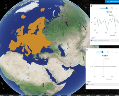 https://www.magister.fi/wp-content/uploads/2025/03/coverage-analysis-kuva.png
442
687
Hilla Koskelainen
https://www.magister.fi/wp-content/uploads/2018/11/magister_logo_white.png
Hilla Koskelainen2025-03-10 13:00:102025-09-04 14:29:25Simulating satellite coverage for more accurate services
https://www.magister.fi/wp-content/uploads/2025/03/coverage-analysis-kuva.png
442
687
Hilla Koskelainen
https://www.magister.fi/wp-content/uploads/2018/11/magister_logo_white.png
Hilla Koskelainen2025-03-10 13:00:102025-09-04 14:29:25Simulating satellite coverage for more accurate services